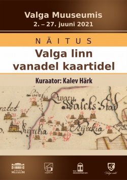
The first mention of the name Valga dates from the second half of the 13th century, some according to sources from 1266. The first mention of the city of Valga on the map is Olaus Magnus’ “Carta Marinas” from 1539. The first map detailing the entire territory of the city was made in 1683 and a little later, in 1693, also for the settlement of Luke on the other bank of the Konnaoja (today the city of Valka). The development of the city selected from later maps for the exhibition is best characterized by the 18th-20th centuries. century maps. The expansion of city boundaries and buildings can be seen, as well as the areas taken away from the city by drawing the Estonian-Latvian border. On the other side of the 20th century, the master plans of that time are represented, which on the one hand are astonishingly radical and grandiose, and on the other hand characterize the (sometimes chaotic) way of thinking of the Soviet era.
Gallery name: Valga Muuseum
Address: Vabaduse 8, Valga
Opening hours: Tue-Fri 11:00 - 18:00, Sat 10:00 - 15:00
Open: 02.06.2021 - 27.06.2021